
The Philippines has 7,641 islands, and the most common mistake visitors make is treating that number as a checklist. Two weeks, six islands, nine flights, a bag that never quite gets unpacked, and a trip remembered mostly as departure lounges. The archipelago punishes that approach more than most countries, because moving between islands here is rarely quick and almost never fully predictable.
Slow travel in the Philippines is not a lifestyle preference. It is the practical response to the geography. Pick one island group, or two that sit next to each other. Give each place three or four nights instead of two. Leave gaps in the plan for the ferry that does not sail and the afternoon you decide not to move at all. Do that, and the country opens up in a way it simply cannot when you are always packing.
This guide is about where to go and when: season by season, region by region, with the timing quirks that generic advice tends to flatten. It is written for people who would rather know one island properly than see six of them from a boat window.
An archipelago is not a country you can "do"
Look at a map of the Philippines and the scale is easy to misjudge. From Basco in the far north to Tawi-Tawi in the deep south is roughly the distance from London to Casablanca. The three island groups (Luzon in the north, the Visayas in the middle, Mindanao in the south) are not neighbourhoods of one city. They are distinct worlds with different landscapes, different languages, different rainfall patterns and, frankly, different reasons to visit.
There are more than 180 living languages here. Tagalog and Cebuano are the two biggest, English is widely spoken and used in signage and administration, and Spanish and American colonial history sit visibly in the architecture, the food and the calendar of fiestas. None of that reveals itself at speed. It shows up over a few unhurried days in one town, when you eat at the same carinderia twice and the owner starts explaining what she cooked differently the second time.
The practical rule we would offer is simple. For a first trip of two weeks or less, choose one region and at most one neighbouring add-on. Palawan and nothing else. The Visayas and nothing else. Northern Luzon and nothing else. The impulse to combine Banaue's rice terraces with El Nido's lagoons and Siargao's surf in fourteen days is understandable, and it produces a trip made almost entirely of transit. Domestic flights are cheap enough to make it look feasible on a spreadsheet; they are not cheap in hours, in cancellations, or in the low-grade fatigue that flattens everything you see.
If you want to sanity check what a slower trip actually costs, our guide to trip costs and budgets in the Philippines breaks it down honestly. One thing worth noting up front: fewer flights and longer stays usually make a Philippine trip cheaper, not more expensive. Weekly accommodation rates, local transport instead of private transfers, and eating where people actually eat all pull the daily number down.
One request. Up to five tailored proposals.
Skip contacting agencies one by one — share your trip once and let up to five trusted Philippines agencies come to you. Free, with no obligation.
Get my free quotesWhen to go: the seasons, honestly
The broad shape is easy. The dry season runs roughly from November to May, with the most reliable weather from December to April. The wet season and the typhoon season overlap and run roughly from June to November, peaking between July and October. Around seventy percent of tropical cyclones that affect the country form in that four-month window, and the Philippines sits directly in the western Pacific's busiest storm corridor. It is the most typhoon-exposed country on earth, and pretending otherwise does no one any favours.
That is the headline. The complication, and the thing most short guides skip, is that the Philippines does not have one climate. It has several, and they are close to inverted in places.
Western-facing areas, which include Manila, most of west Luzon, Palawan, Boracay and the western Visayas, have a clear dry season from roughly November to April and a genuine wet season driven by the southwest monsoon, the habagat, from June to October. This is the pattern most travel advice describes.
The eastern seaboard is different. Eastern Visayas, the Pacific coast of Luzon, the Bicol region's eastern edge, Siargao and much of eastern Mindanao have no true dry season at all. Their heaviest rain comes with the northeast monsoon, the amihan, from around November to January, precisely when the western half of the country is at its best. This is why a January trip that works beautifully in El Nido can be a wet, grey disappointment in Siargao, and why "December to April is the best time to visit the Philippines" is only accurate for about half of it.
Southern Mindanao, meanwhile, sits mostly below the typhoon belt and gets rain spread fairly evenly through the year, with no dramatic peak in either direction.
December to February brings the coolest, driest air over most of the country, the amihan blowing steadily from the northeast. It is peak season, it is when the highland towns are genuinely cold at night, and it is the height of the festival calendar. Christmas and New Year see the whole country on the move; domestic flights and ferries sell out weeks ahead and prices climb sharply. If you can travel in the second half of January or in February instead, you get similar weather with noticeably less pressure on everything.
March to May is the hot, dry heart of the year, building to genuinely fierce heat by late April and May. Seas are at their calmest, visibility for diving is often at its best, and this is the classic window for Batanes, for Malapascua's thresher sharks and for island-hopping generally. It is also Philippine summer holidays, so domestic beach destinations fill up with Filipino families, especially around Holy Week. Holy Week is worth planning around deliberately: it is culturally extraordinary and logistically brutal, with the entire country travelling at once.
June to September is the southwest monsoon. Rain in this season is typically not constant drizzle but heavy afternoon downpours with bright mornings in between, and the landscape is at its greenest. Prices drop, crowds thin, and the rice terraces in northern Luzon are luminous. The risk is real, though: this is the period when Luzon and the northern Visayas take most of their direct typhoon hits, and a single storm can shut down flights and ferries for several days.
October and November are the shoulder, and the shape of them varies a lot year to year. Late-season storms tend to track further south, which pushes exposure toward the Visayas and northern Mindanao. By late November the amihan is usually setting in over the west and the dry season is arriving. Travellers who go in mid to late November often get excellent value: mostly dry weather in the west, low crowds, and green landscapes that have not yet browned off.
Two practical notes. First, a typhoon does not have to make landfall near you to ruin a plan; a storm several hundred kilometres away can cancel ferries and ground small aircraft on a clear-looking day. Second, PAGASA (the national weather agency) publishes forecasts and storm signals in plain English, and it is the source worth trusting over aggregator apps.
Northern Luzon: rice terraces, pine forests and the Cordillera
The mountainous north of Luzon is the part of the Philippines that surprises people who came expecting only beaches. This is a region of pine ridges, cold mornings, terraced valleys and a strong Indigenous cultural presence that was never fully colonised.
The Ifugao rice terraces around Banaue are the anchor. Carved into the mountainsides over roughly two thousand years and still farmed by hand, they are a UNESCO World Heritage property, and the inscribed clusters (Batad, Bangaan, Mayoyao, Hungduan and Nagacadan) are not the roadside viewpoints most day-trippers photograph. Batad in particular rewards the effort of getting there: an amphitheatre of stone-walled terraces reached on foot, best experienced by staying overnight in the village rather than turning around at lunchtime. Timing matters aesthetically. The terraces are flooded and mirror-like around January and February, an intense green from around March to May, and gold at harvest around June and July. After harvest, they are brown stubble, still impressive but far less photogenic.
Sagada, further west in Mountain Province, is a cooler, quieter place of limestone caves, waterfalls and the hanging coffins of the Igorot people, still visible on the cliffs at Echo Valley. It has become popular with domestic travellers, which means weekends and holidays are busy while a Tuesday in July can feel almost empty. Bontoc, between the two, is a working market town and a good place to understand the region as somewhere people live rather than somewhere people visit.
Vigan, down on the coast in Ilocos Sur, is a different proposition: a remarkably intact Spanish colonial town of cobbled streets and merchant houses, also UNESCO-listed. It is best in the early morning and after dark, when the tour buses have gone. Combined with the Ilocos coast (Laoag, the sand dunes at Paoay, the surf town of San Juan in La Union further south), it makes a coherent overland route.
Northern Luzon is best from around November to April. December to February is cold at altitude, sometimes near freezing before dawn in Sagada and Baguio, and you will want more layers than you expect to need in a tropical country. The mountain roads are genuinely mountainous, and travel times here are slow: Manila to Banaue is a long overnight bus, and Banaue to Sagada, though short on a map, takes most of a morning. This is a region that rewards a week, not a weekend.
Get matched with up to 5 trusted Philippines agencies
- Free
- No obligation
- Up to 5 agencies
Manila and the corridor south
Manila gets dismissed too casually. It is congested, hot and hard to love at first sight, but it is also the most interesting city in the country, and giving it two nights rather than treating it as an airport with a hotel attached changes a trip's texture. Intramuros, the walled Spanish core, is best explored slowly and ideally by bamboo bicycle with a guide who knows the layers of the place. Escolta's art deco buildings, the food and antiques of Quiapo, the Ayala Museum and the National Museum complex all repay time. Manila is also where the country's food culture is most legible, which our guide to Filipino food is a good companion to.
South of the capital, Tagaytay looks down over Taal Lake and the volcano inside it, an active caldera that is monitored closely and has produced eruptions and access restrictions in recent years. Check the current alert level before planning anything on the island itself. Further south, Batangas and the Anilao coast are the country's most accessible serious dive region, particularly for macro photography, and reachable in a morning from Manila.
The unglamorous truth about Manila's surroundings is that they work best as bookends rather than a destination in themselves. Traffic in the metropolitan area is severe enough that the distance between an intention and an arrival can be three hours.
Bicol: volcanoes, whale sharks and a region people skip
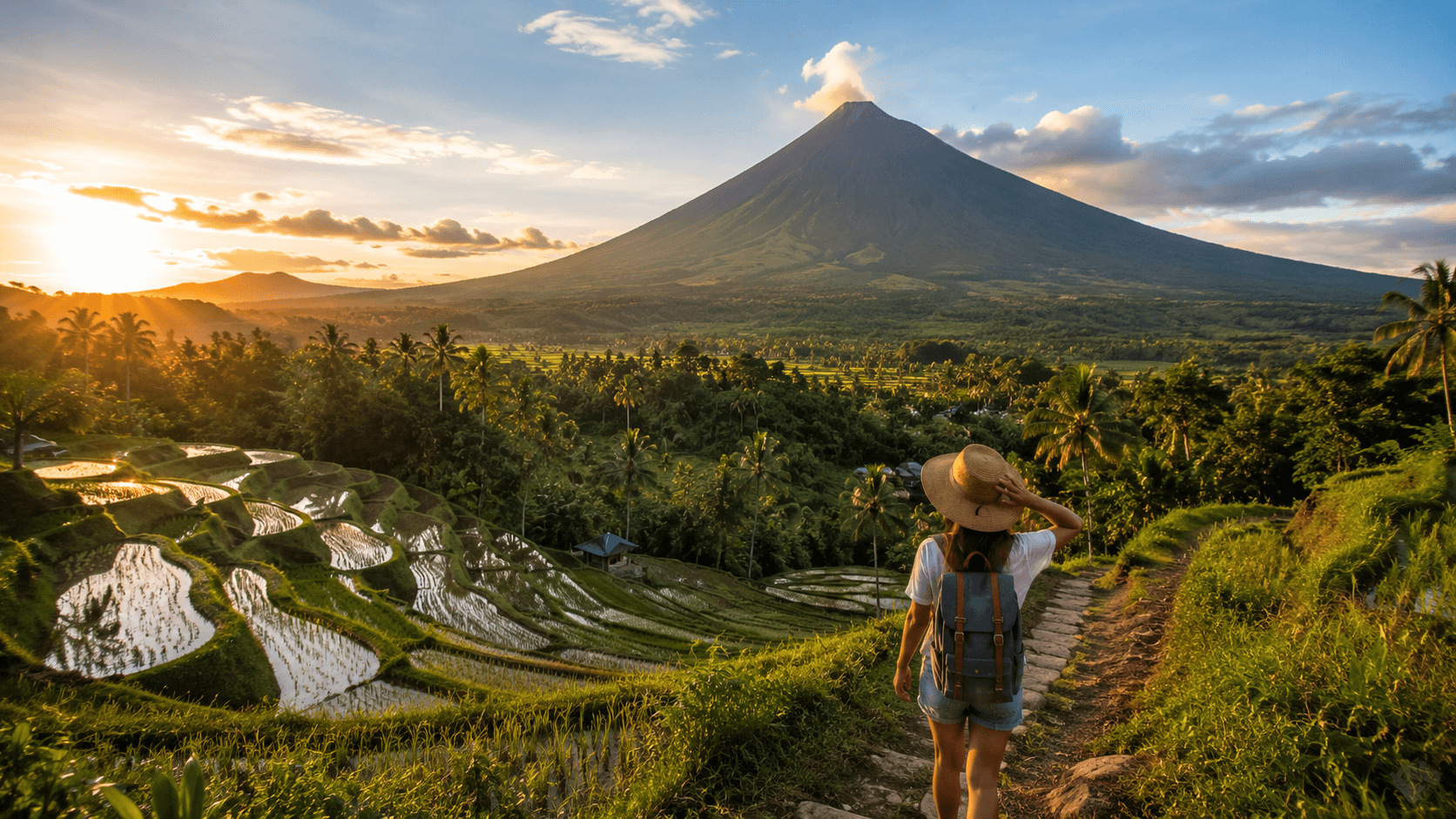
Bicol, the long southeastern peninsula of Luzon, is one of the country's great underrated regions and one of the easiest to reach overland. Mayon volcano near Legazpi is the reason most people come: a near-perfect cone that, on a clear morning, looks unreal. Mayon is active and its alert level changes; when it is restless, the permanent danger zone expands and climbing is prohibited. Even from a distance, the ruins of Cagsawa church half-buried in old lahar tell the story clearly enough.
Donsol, in Sorsogon, is the other draw. Whale sharks pass through from roughly mid-November to mid-May, with the strongest sightings between February and April. Donsol matters because of how the interaction is run: swimming only, no touching, no feeding, limited numbers per boat with a trained Butanding Interaction Officer. It is a genuinely wild encounter, which means some days you see several animals and some days none. That honesty is the point, and it stands in sharp contrast to provisioned feeding operations elsewhere in the country where whale sharks are baited into a fixed area for guaranteed viewing. We would strongly encourage the former and avoid the latter.
Bicol is also where Filipino food gets its heat: coconut milk, chilli and taro leaves in laing and Bicol Express. And nearby, Caramoan's limestone coast offers island-hopping without El Nido's crowds, though the roads in are slow.
Best timing for Bicol is a narrow window. It is on the eastern side, so it catches both typhoons and the amihan rains; February to May is by far the most reliable, and it happens to coincide with peak whale shark season. Bicol also fits neatly into the wider picture of places in the Philippines that stay quiet even in high season.
Palawan: the long island that deserves more than four nights
Palawan is the province most first-time visitors picture, and it is genuinely spectacular: a long, thin island trailing south-west toward Borneo, fringed by limestone karst, with some of the clearest water in Southeast Asia. It is also the region where the gap between a rushed trip and a slow one is widest.
El Nido, in the north, sits beneath dramatic cliffs and gives access to Bacuit Bay's lagoons. The standard tours (labelled A, B, C and D) are heavily trafficked in high season, and the Big Lagoon and Small Lagoon can feel like queues on the water in March. The fix is not to skip El Nido but to change how you do it: stay longer, go out on a private or small-group boat that reverses the standard route, spend a day on the mainland beaches at Nacpan or Duli, and accept that the best hours are early and late. An Eco-Tourism Development Fee applies to visitors and is valid for a set number of days; most operators include it, but confirm.
Coron, on Busuanga to the north-east, is a different kind of place: better known for wreck diving on the Japanese fleet sunk in 1944, for Kayangan Lake and Barracuda Lake's thermoclines, and for the Calamian Islands generally. The Tagbanua people manage several of the key sites, and access rules reflect that. Coron and El Nido are connected by fast ferry in around three and a half to four hours, weather permitting, and that qualifier does real work between June and November.
Port Barton, halfway down the west coast, is the counter-argument to both. It is smaller, slower, has limited electricity hours in places, and delivers much of the same island-hopping with a fraction of the boats. Sabang, further south, is the base for the Puerto Princesa Subterranean River, a UNESCO World Heritage site and one of the world's longest navigable underground rivers. Visitor numbers are capped at roughly 900 per day and a permit is compulsory, with no permit meaning no entry. Book well ahead in the December to May peak; a good local operator will secure the slot for you.
Palawan's dry season runs roughly November to May, and the island is comparatively sheltered from typhoons because most Pacific storms have crossed land and weakened before reaching it. That makes it the most reliable major destination during the wet season, though the southwest monsoon still brings rough seas that cancel boats. Four nights in Palawan is a taste. Ten is a trip.
The Visayas: the archipelago's connected middle
If you want variety without long flights, the Visayas is the answer. The central islands sit close enough together that ferries do most of the work, and you can build a genuinely slow, mostly overland-and-water route without ever returning to Manila.
Cebu is the hub, with the country's second airport and a city that is both the oldest Spanish settlement in the Philippines and a modern commercial centre. South Cebu has Moalboal's sardine run, a vast bait ball a short swim from shore, and the canyoneering at Kawasan Falls, which has become extremely popular and, in high season, extremely crowded. North of Cebu, Malapascua is the only place in the world where divers reliably see thresher sharks, rising from the deep at Monad Shoal at dawn most days of the year. Bantayan, on the same northern end, is the opposite: flat, white-sand, and unhurried.
Bohol is a two-hour ferry from Cebu City and holds the Chocolate Hills, the tarsier sanctuaries at Corella and Loboc (choose the ones that prohibit handling and flash photography), Anda's quiet east coast and the diving at Balicasag off Panglao. Siquijor, another short hop, has a reputation across the Philippines for folk healing and mysticism and is, in practice, a small island of waterfalls, empty coast roads and one of the most pleasant places in the country to do very little for four days.
Negros gives you Apo Island, a community-managed marine sanctuary with sea turtles that are almost guaranteed and coral that has recovered impressively, plus Dumaguete as a university town with a good food scene and Bacolod on the other coast. Panay holds Iloilo, an increasingly interesting city of heritage churches and excellent food, and, at its north-western tip, Boracay.
Boracay divides opinion. After a six-month closure and rehabilitation in 2018, it came back cleaner and better regulated, with an environmental fee and DOT-accredited accommodation now required. White Beach is still one of the finest beaches anywhere, and it is still a busy, developed resort island. That is not a criticism, only a description; go knowing which of those two facts matters more to you.
The Visayas are best from around December to May on the western side, with March to June bringing the calmest seas for diving. Remember the eastern Visayas exception: Samar and Leyte follow a different pattern and are wettest from November to January.
Siargao and the Mindanao islands
Siargao has changed a great deal in ten years, from a surf secret to an international destination with direct flights from Manila and Cebu. Cloud 9 is the famous right-hander, but the island is more than its waves: Sugba Lagoon, the tidal rock pools at Magpupungko, the mangrove forests and the small islands offshore. Surf season runs roughly August to November, with the biggest Pacific swells in September and October. For everything else, March to May is the sweet spot, with the driest weather, calmest seas and beginner-friendly waves. Note the climate pattern here: Siargao's wettest stretch is December and January, which catches out travellers assuming Philippine dry season applies everywhere.
Camiguin, a small volcanic island off northern Mindanao, is one of the most likeable places in the country: seven volcanoes on an island you can circle in a couple of hours, hot and cold springs, a sunken cemetery marked by a cross in the sea, and almost no crowds. It is reached by ferry from Balingoan or by air via Cagayan de Oro.
Mainland Mindanao is a more complicated conversation and deserves a straight answer rather than a euphemism. Several Western governments maintain elevated advisories for parts of the island, with the Sulu archipelago and Marawi at the most serious level, and much of the mainland at "reconsider travel" or similar. Siargao, Dinagat and Camiguin are commonly carved out as exceptions in those advisories, and the standard guidance is to reach them by air rather than by sea from mainland Mindanao. Davao City's status has shifted more than once in recent years. Advisories change, they are not the whole truth about a place, and many parts of Mindanao are welcoming and entirely calm in practice. But they do affect travel insurance validity, which is the practical reason to check your own government's current advice before committing, and to talk to an operator who works in the region rather than relying on a forum post from three years ago.
Batanes: the far north, and the hardest place to reach
Batanes is the northernmost province, ten small islands closer to Taiwan than to Manila, and unlike anywhere else in the country: rolling green hills, stone houses with metre-thick walls built to survive typhoons, cliffs dropping into a sea that is often too rough for boats. The Ivatan culture here is distinct, and the famous honesty stores, unattended shops where you leave payment in a box, are real rather than a tourist gimmick.
The catch is access. Flights go from Manila and Clark to Basco, they are relatively expensive by Philippine standards, and they are frequently cancelled for weather. Getting between Batan and Sabtang islands depends on faluwa boats crossing an often violent channel. February to May is the best window, with April and May the most reliable; the typhoon season here is severe and prolonged.
Batanes needs slack in the schedule. Budget a minimum of four nights and, if you have an international flight to catch, at least two days of buffer in Manila afterwards. It is not a place to visit at the end of a tight itinerary.
Putting it together: slow routes for one, two and three weeks
One week. Choose a single island or a tight cluster. Palawan north (Coron and El Nido, with the ferry between them), or Bohol plus Siquijor, or Cebu south plus Malapascua. Three or four nights in each of two places, with one travel day in between. Anything more ambitious than this in seven days is a transit itinerary wearing a holiday's clothes.
Two weeks. Two regions at most, and ideally two that connect logically. Northern Luzon overland (Manila, Banaue, Sagada, Vigan, back to Manila) is a satisfying self-contained loop. Or the central Visayas by ferry: Cebu, Bohol, Siquijor, Negros and Apo Island, moving on water rather than by air. Or Palawan properly: Coron, El Nido, Port Barton, Sabang and Puerto Princesa, top to bottom, at a human pace.
Three weeks. Now you can pair two regions honestly. Northern Luzon and Palawan. Or the Visayas plus Siargao, which works especially well in the March to May window when both are at their best simultaneously. Or Bicol and the Visayas, connected by the ferry crossing at Matnog to Samar and Leyte if you want a genuinely overland trip through the middle of the country.
Whichever shape you choose, build in two things: a spare day per region for weather, and at least one place where you stay four nights or more. That longer stay is where the trip stops being sightseeing. If you would like help turning this into something specific, our plan your journey page is the place to start.
Getting around: flights, ferries and the weather's veto
Domestic flights are the backbone. Philippine Airlines, Cebu Pacific and AirSWIFT connect Manila and Cebu to most regional airports, and fares booked ahead can be very cheap. Baggage allowances on budget carriers are strict and small aircraft to places like El Nido and Batanes have low weight limits, sometimes ten to fifteen kilograms including cabin bags. Weigh your luggage before you go.
Ferries range from large overnight vessels between major ports to fast craft on routes like Cebu to Bohol and El Nido to Coron, down to small outrigger bangkas for short hops. The Philippine Coast Guard suspends sailings when sea conditions warrant, which is a good thing and also the single most common cause of a disrupted itinerary. Anyone who has waited three days in a port town for a swell to drop learns to build in buffer days.
On land, buses cover long distances (often overnight and often aggressively air-conditioned), jeepneys and multicabs handle local routes, and tricycles do the last mile. Habal-habal motorbike taxis serve mountain and rural routes where nothing else fits. Renting a scooter is common on smaller islands; make sure your travel insurance actually covers it and that you hold the right licence, because many policies do not.
The single most useful planning habit is this: never schedule an international departure for the day after an inter-island journey. Give yourself a night in Manila or Cebu. It costs one hotel night and removes the biggest source of stress in a Philippine trip. A good local operator will insist on this too, and if you want introductions, we list vetted Philippine travel agencies who plan trips this way.
Festivals worth planning around
The Philippine fiesta calendar is one of the richest in Asia, and January is its densest month.
Ati-Atihan in Kalibo, Aklan, held around the third Sunday of January, is the oldest of them: days of drumming, soot-blackened faces and a street procession that anyone can join. It is less polished and more participatory than its bigger cousins.
Sinulog in Cebu City, also the third Sunday of January, honours the Santo Niño and draws crowds in the millions, with a nine-day novena leading to the grand parade. Book accommodation months ahead or stay outside the city.
Dinagyang in Iloilo follows the fourth Sunday of January, tightly choreographed and visually extraordinary.
Panagbenga, Baguio's flower festival, runs through February and peaks with a float parade at the end of the month, coinciding with the Cordillera's best weather.
MassKara in Bacolod, in the second half of October, was born out of hardship in the 1980s and became a festival of smiling masks. It is one of the few major fiestas in the wet-season half of the year.
Beyond these, almost every town has its own patronal fiesta, and the whole country slows down for Holy Week and for Christmas, when celebrations begin in September. Travelling during a fiesta means crowds, higher prices and full transport. It also means seeing a place at its most itself. Both things are true; choose deliberately.
Travelling responsibly here
The Philippines is on the front line of climate change and of tourism's mixed effects, and a few choices genuinely matter.
Choose wildlife encounters carefully. Donsol's non-feeding whale shark interaction, Apo Island's community-managed sanctuary and tarsier sanctuaries that ban handling are the good models. Provisioned whale shark feeding and any operation that lets you touch animals are not. Coral is fragile; do not stand on it, and use reef-safer sunscreen or, better, a rash guard.
Spend locally. Staying in family-run accommodation, eating at neighbourhood carinderias and hiring local guides keeps money in the community rather than routing it offshore. In places like Batad and Siquijor, that difference is the entire local economy.
Respect the rules that exist for good reasons: the permit caps at the Underground River, the environmental fees in El Nido and Boracay, the closed seasons on certain dive sites. They exist because these places were being loved to death.
And go slowly. It is not only more pleasant; it is measurably lower-impact. Fewer domestic flights, longer stays and local transport reduce a trip's footprint more than any single offsetting purchase. That principle sits at the heart of our slow travel charter, and it is why we keep repeating the same unglamorous advice: go to fewer places, and stay longer in each.
Frequently Asked Questions
When is the best time to visit the Philippines?
For most of the country, December to April is the most reliable window, with January to March offering the best combination of dry weather, calm seas and low storm risk. But this only holds for the western-facing half of the archipelago. Siargao, the eastern Visayas and much of eastern Mindanao are at their wettest from November to January and are usually better from March to May. Decide where you are going first, then pick your dates.
How risky is travelling during typhoon season?
Between June and November there is a real chance of disruption, and roughly seventy percent of the country's cyclones form between July and October. That said, most of the season is not typhoon weather; it is bright mornings and heavy afternoon rain. Prices are lower, crowds are thinner and the landscape is at its best. If you travel then, choose sheltered regions like Palawan, keep your itinerary short on inter-island moves, build in two or three buffer days, buy insurance that covers weather disruption, and follow PAGASA rather than a generic weather app.
How many islands should I visit in two weeks?
Two regions at most, and within those, three or four bases. A realistic and rewarding two-week trip might be Coron, El Nido and Port Barton, or Cebu, Bohol and Siquijor. Every island change costs the better part of a day once you count transfers, waiting and check-ins, so five islands in fourteen days means roughly five days of your holiday spent in transit.
Do I need a visa for the Philippines?
Citizens of around 150 to 160 countries, including the UK, the US, Canada, Australia and the EU, receive 30 days visa-free on arrival, extendable in-country. You will need a passport valid for at least six months beyond your stay and proof of onward travel. All arrivals must also complete the free eTravel registration online within 72 hours of departure, which generates a QR code for immigration. Use only the official government site; a number of copycat sites charge for the same free form. Requirements do change, so confirm with an official source close to your travel date.
Is the Philippines safe for travellers?
For the overwhelming majority of visitors, yes. The main practical risks are road safety, sea conditions and petty theft in crowded urban areas, in roughly that order. The significant exception is parts of Mindanao, where several governments maintain elevated advisories, most seriously for the Sulu archipelago and Marawi. Siargao, Dinagat and Camiguin are typically excluded from those warnings and are reached by air. Check your own government's current advice before booking, mainly because advisory levels can affect whether your travel insurance is valid.
Which region should I choose for a first trip?
If you want beaches and dramatic seascapes with a simple itinerary, Palawan. If you want variety, easy ferry connections and a mix of coast, culture and diving, the Visayas. If you want mountains, terraces, cool air and a strong cultural focus rather than a beach, northern Luzon. Trying to combine all three on a first two-week trip is the most common planning mistake we see.
Can I travel around the Philippines without flying?
Yes, and it is one of the more rewarding ways to do it. A dense network of ferries links the islands, and it is entirely possible to travel from Manila through Bicol, across to Samar and Leyte, and down into Cebu and the Visayas using only buses and boats. It takes longer, and you need flexibility for weather cancellations, but it gives you a sense of the archipelago's scale and connectedness that flying erases completely. Allow roughly half again as much time as a flying itinerary would need.